
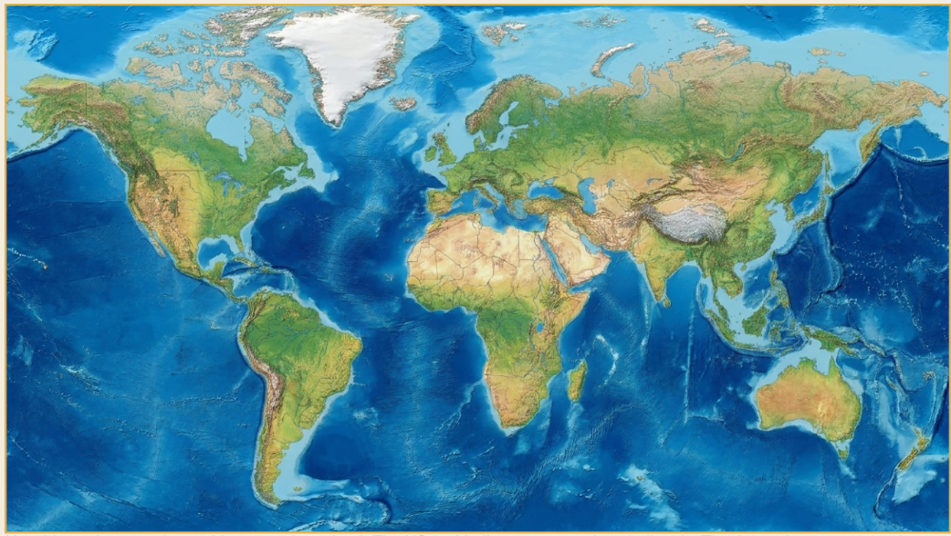
WORLD MAP CINEMATIC ZOOM
Image-to-video kit · 16:9 · 10s · made in Google Omni / Veo
THE BASE MAP
Use this equirectangular world map as the upload. The US and India prompts work on it directly. The Antarctica prompt needs a map version that includes the Antarctic landmass at the bottom.
HOW TO MAKE IT
1 Open Google Omni / Veo (or any image-to-video tool that accepts a reference image).
2 Upload the world map image above as the starting frame / reference image.
3 Copy ONE of the three prompts on the next pages (United States, India, or Antarctica).
4 Paste it into the prompt box and generate. Keep the output at 16:9, ~10 seconds.
5 Optional but recommended: for a crisp, accurate glowing border and clean text, add those as
overlays in CapCut / After Effects on top of the generated zoom, instead of relying on the model
to draw them.
6 Add your sound design — the prompt lists the cues (rumble, whoosh, shimmer, boom) so you
know what to layer.
Tip: keep one keyword for these reels (e.g. comment “MAP” or “MOTION”) so your DM automation always catches it.
PROMPT 1 — UNITED STATES
Copy everything inside the box. Paste into Omni/Veo with the map uploaded.
{
“task”: “image_to_video_motion_graphics”,
“source_image”: “world_map.jpg (equirectangular world map)”,
“target”: “United States (upper-left, mainland between Canada and Mexico)”,
“duration_seconds”: 10,
“aspect_ratio”: “16:9”,
“resolution”: “3840×2160”,
“fps”: 30,
“style”: “premium cinematic map motion graphics, satellite-zoom feel”,
“camera”: {
“start”: “full world map in frame, static for a beat”,
“move”: “smooth cinematic push-in toward the upper-left, descending onto the United States”,
“end”: “settles framed on the United States, slight slow drift to keep it alive”,
“easing”: “slow ease-in, gentle ease-out on arrival, subtle motion blur during the move”
},
“timeline”: [
{ “t”: “0.0-1.5s”, “action”: “full map holds, faint atmospheric haze and slow ocean shimmer”,
“sound”: [“deep cinematic sub-rumble”, “soft ambient drone”, “subtle wind”] },
{ “t”: “1.5-5.5s”, “action”: “camera pushes in toward the United States with motion blur; edges softly blur
(depth of field)”,
“sound”: [“rising whoosh / air-rush building”, “low riser swelling”] },
{ “t”: “5.5-7.0s”, “action”: “settles on the United States; glowing outline traces west to east along the US
border + coastline with soft bloom”,
“highlight”: { “boundary”: “animated glowing border tracing the US outline (coastline + Canada/Mexico
borders)”,
“color”: “bright cyan-white glow (or gold #E0B04B)”,
“effect”: “soft outer glow + faint inner fill pulse, light particles along the line” },
“sound”: [“shimmer as line draws”, “soft chime on completion”, “energy hum”] },
{ “t”: “7.0-10.0s”, “action”: “text label fades and scales in with subtle glow; boundary pulse holds; slow
drift”,
“text”: { “content”: “UNITED STATES”, “style”: “clean bold uppercase, white or gold with soft glow”,
“animation”: “fade + slight scale-up, ease-out”, “subline”: “USA” },
“sound”: [“soft text whoosh-in”, “ambient swell resolving”, “low boom on text land”] }
],
“atmosphere”: “subtle cloud wisps, gentle light glints on water, faint vignette, cinematic grade”,
“music”: “minimal epic / documentary tone, builds with the push-in, resolves at 10s”,
“negative_prompt”: “no distorted continents, no warped coastline, no jittery camera, no text errors, no
flicker, no extra labels, no clutter, no watermark, no fake landmasses, no incorrect borders”
}
PROMPT 2 — INDIA
Copy everything inside the box. Paste into Omni/Veo with the map uploaded.
{
“task”: “image_to_video_motion_graphics”,
“source_image”: “world_map.jpg (equirectangular world map)”,
“target”: “India (center-right, peninsula extending south into the Indian Ocean)”,
“duration_seconds”: 10,
“aspect_ratio”: “16:9”,
“resolution”: “3840×2160”,
“fps”: 30,
“style”: “premium cinematic map motion graphics, satellite-zoom feel”,
“camera”: {
“start”: “full world map in frame, static for a beat”,
“move”: “smooth cinematic push-in toward the center-right, descending onto India”,
“end”: “settles framed on India, slight slow drift to keep it alive”,
“easing”: “slow ease-in, gentle ease-out on arrival, subtle motion blur during the move”
},
“timeline”: [
{ “t”: “0.0-1.5s”, “action”: “full map holds, faint atmospheric haze and slow ocean shimmer”,
“sound”: [“deep cinematic sub-rumble”, “soft ambient drone”, “subtle wind”] },
{ “t”: “1.5-5.5s”, “action”: “camera pushes in toward India with motion blur; edges softly blur (depth of
field)”,
“sound”: [“rising whoosh / air-rush building”, “low riser swelling”] },
{ “t”: “5.5-7.0s”, “action”: “settles on India; glowing outline traces north to south along the border and
coastline with soft bloom”,
“highlight”: { “boundary”: “animated glowing border tracing India (Himalayan border + peninsular
coastline to the southern tip)”,
“color”: “bright cyan-white glow (or gold #E0B04B)”,
“effect”: “soft outer glow + faint inner fill pulse, light particles along the line” },
“sound”: [“shimmer as line draws”, “soft chime on completion”, “energy hum”] },
{ “t”: “7.0-10.0s”, “action”: “text label fades and scales in with subtle glow; boundary pulse holds; slow
drift”,
“text”: { “content”: “INDIA”, “style”: “clean bold uppercase, white or gold with soft glow”,
“animation”: “fade + slight scale-up, ease-out”, “subline”: “Bharat” },
“sound”: [“soft text whoosh-in”, “ambient swell resolving”, “low boom on text land”] }
],
“atmosphere”: “subtle cloud wisps, gentle light glints on water, faint vignette, cinematic grade”,
“music”: “minimal epic / documentary tone, builds with the push-in, resolves at 10s”,
“negative_prompt”: “no distorted continents, no warped coastline, no jittery camera, no text errors, no
flicker, no extra labels, no clutter, no watermark, no fake landmasses, no incorrect borders”
}
PROMPT 3 — ANTARCTICA
Use a world map that INCLUDES Antarctica at the bottom, then copy and paste this.
{
“task”: “image_to_video_motion_graphics”,
“source_image”: “world_map.jpg (equirectangular world map)”,
“target”: “Antarctica (bottom of the map — NOTE: use a world map that INCLUDES Antarctica)”,
“duration_seconds”: 10,
“aspect_ratio”: “16:9”,
“resolution”: “3840×2160”,
“fps”: 30,
“style”: “premium cinematic map motion graphics, satellite-zoom feel”,
“camera”: {
“start”: “full world map in frame, static for a beat”,
“move”: “smooth cinematic push-in toward the bottom of the map, descending onto Antarctica”,
“end”: “settles framed on Antarctica, slight slow drift to keep it alive”,
“easing”: “slow ease-in, gentle ease-out on arrival, subtle motion blur during the move”
},
“timeline”: [
{ “t”: “0.0-1.5s”, “action”: “full map holds, faint atmospheric haze and slow ocean shimmer”,
“sound”: [“deep cinematic sub-rumble”, “soft ambient drone”, “subtle wind”] },
{ “t”: “1.5-5.5s”, “action”: “camera pushes in toward Antarctica with motion blur; edges softly blur (depth
of field)”,
“sound”: [“rising whoosh / air-rush building”, “low riser swelling”] },
{ “t”: “5.5-7.0s”, “action”: “settles on Antarctica; glowing outline traces along the entire Antarctic
coastline with soft bloom”,
“highlight”: { “boundary”: “animated glowing outline tracing the Antarctic coastline”,
“color”: “bright cyan-white glow (or gold #E0B04B)”,
“effect”: “soft outer glow + faint inner fill pulse, light particles along the line” },
“sound”: [“shimmer as line draws”, “soft chime on completion”, “energy hum”] },
{ “t”: “7.0-10.0s”, “action”: “text label fades and scales in with subtle glow; boundary pulse holds; slow
drift”,
“text”: { “content”: “ANTARCTICA”, “style”: “clean bold uppercase, white or gold with soft glow”,
“animation”: “fade + slight scale-up, ease-out”, “subline”: “70% of Earth’s fresh water” },
“sound”: [“soft text whoosh-in”, “ambient swell resolving”, “low boom on text land”] }
],
“atmosphere”: “subtle cloud wisps, gentle light glints on water, faint vignette, cinematic grade”,
“music”: “minimal epic / documentary tone, builds with the push-in, resolves at 10s”,
“negative_prompt”: “no distorted continents, no warped coastline, no jittery camera, no text errors, no
flicker, no extra labels, no clutter, no watermark, no fake landmasses, no incorrect borders”
}
Universal Cinematic Country Zoom Prompt
Create a premium cinematic documentary-style map animation that begins with a high-resolution equirectangular world map and smoothly zooms into **[TARGET COUNTRY]**.
The animation opens with the entire world map perfectly centered in a clean 16:9 composition. Hold this wide view for approximately 1–2 seconds while subtle atmospheric haze, gentle cloud movement, realistic ocean shimmer, and cinematic HDR lighting create a high-end documentary atmosphere. The camera remains completely stable.
The camera then begins a smooth satellite-style push-in toward **[TARGET COUNTRY]**, following the shortest natural flight path across the globe. The movement should feel identical to a Google Earth or National Geographic cinematic flyover, with seamless altitude transitions, realistic perspective changes, soft motion blur, subtle depth of field, and elegant ease-in/ease-out interpolation. Every movement must be fluid, precise, and professionally animated with absolutely no jitter or sudden speed changes.
As the destination approaches, the camera gradually slows and settles into a perfectly framed aerial view of **[TARGET COUNTRY]**. Maintain a gentle floating drift to keep the shot alive without distracting movement.
Immediately after the camera settles, the country’s international borders are traced by an elegant animated glowing line. The border should be drawn naturally around the country’s entire outline, including coastlines and all international land borders where applicable.
Border Animation:
• Bright cyan-white glow or premium gold (#E0B04B)
• Soft bloom with subtle outer glow
• Tiny light particles traveling along the tracing path
• Gentle pulse after the outline completes
• Optional soft interior highlight that slowly fades
As the border animation completes, major cities softly illuminate with subtle satellite-style light points. Rivers, lakes, coastlines, and mountain ranges become slightly more visible through refined lighting without cluttering the map.
Around 70% through the animation, the country title appears.
Main Title:
“[TARGET COUNTRY]”
Subtitle:
“[SHORT NAME / ABBREVIATION / REGION]” (optional)
Typography:
Modern bold uppercase
Clean documentary style
White or premium gold
Soft cinematic glow
Fade in while scaling up slightly
Smooth ease-out animation
Lighting:
Realistic atmospheric scattering
HDR sunlight
Natural ocean reflections
Soft volumetric haze
Premium cinematic contrast
Color Grade:
National Geographic quality
Google Earth realism
Rich blue oceans
Natural green and brown land
Warm sunlight
High dynamic range
Broadcast-quality finish
Atmosphere:
Subtle cloud wisps
Gentle atmospheric fog
Ocean shimmer
Soft vignette
Elegant floating particles
Ultra-clean presentation
Camera Style:
Ultra-smooth satellite flyover
Professional documentary motion graphics
Google Earth cinematic zoom
High-altitude aerial transition
No camera shake
No abrupt cuts
Audio Design:
Opening:
• Deep cinematic sub-bass
• Soft ambient drone
• Light atmospheric wind
Zoom:
• Rising air whoosh
• Low cinematic riser
• Gentle energy build
Border Draw:
• Crystal shimmer
• Energy hum
• Soft magical sparkle
Title Reveal:
• Cinematic impact
• Gentle orchestral swell
• Deep cinematic boom
• Ambient resolution
Output Specifications:
Duration: [5–15 seconds]
Resolution: 3840×2160 (4K UHD)
Aspect Ratio: 16:9
Frame Rate: 30 FPS
Quality: Ultra High
Style: Premium Documentary Motion Graphics
Negative Prompt:
No distorted geography.
No incorrect borders.
No inaccurate coastlines.
No warped map projection.
No fake landmasses.
No missing islands.
No stretched textures.
No blurry map.
No excessive saturation.
No camera jitter.
No sudden acceleration.
No flickering.
No low resolution.
No compression artifacts.
No extra labels.
No unnecessary icons.
No watermark.
No UI elements.
No text spelling mistakes.
No unrealistic lighting.
No clutter.
No visual noise.
Universal Country Hold Prompt
Continue seamlessly from the previous map zoom animation.
The camera has already arrived above **[TARGET COUNTRY]** and remains perfectly centered on the country for the entire duration.
Do not zoom out.
Do not zoom further in.
Do not rotate the map.
Do not change the camera angle.
Maintain only an extremely slow cinematic floating drift (less than 2% movement) to keep the shot feeling alive while preserving the country’s position in the center of the frame.
The glowing outline of **[TARGET COUNTRY]** remains visible with a soft pulse every few seconds. The border emits a refined cyan-white glow (or premium gold #E0B04B) with subtle bloom and tiny traveling light particles.
Major cities gently glow with small satellite-style light points. Rivers, lakes, coastlines, and mountain ranges remain naturally visible through realistic shading and HDR lighting.
Soft cloud shadows slowly drift across the landscape while oceans shimmer with subtle sunlight reflections. A light atmospheric haze and gentle vignette create a premium documentary appearance.
The title “**[TARGET COUNTRY]**” stays visible in a clean, modern documentary font with a soft glow. The text remains stable without distracting animation.
Lighting remains consistent with realistic daylight, atmospheric scattering, and high-end Google Earth–style rendering.
The scene should feel calm, elegant, and cinematic, suitable for narration in a professional documentary.
Camera Motion:
• Locked on the country
• Ultra-slow floating drift only
• No additional zoom
• No rotation
• No sudden movement
• No shaking
Atmosphere:
• Soft moving clouds
• Ocean shimmer
• HDR lighting
• Subtle volumetric haze
• Gentle bloom
• Premium cinematic color grading
Output:
Duration: 10 seconds
Resolution: 3840×2160 (4K UHD)
Aspect Ratio: 16:9
Frame Rate: 30 FPS
Negative Prompt:
No camera zoom.
No camera rotation.
No camera shake.
No map distortion.
No incorrect borders.
No flickering.
No extra labels.
No new animations.
No UI elements.
No watermark.
No low resolution.
No compression artifacts.
No visual clutter.
Prompt 1 – World Map → India Cinematic Zoom (10 Seconds)
Create a premium cinematic 10-second documentary-style map animation beginning from a high-resolution equirectangular world map.
The animation opens with the entire Earth map visible in a clean 16:9 composition. Hold this wide shot for approximately 1.5 seconds while subtle atmospheric haze, gentle cloud movement, realistic ocean shimmer, and HDR lighting create a premium documentary atmosphere. The camera remains perfectly stable.
The camera then begins a smooth satellite-style push-in toward South Asia, following a natural flight path and gradually descending toward India. The movement should feel identical to a Google Earth or National Geographic cinematic flyover, featuring seamless altitude transitions, realistic perspective changes, subtle depth of field, elegant motion blur, and smooth ease-in/ease-out interpolation.
As the camera approaches India, it gradually slows and settles into a perfectly framed aerial view of the entire country. The camera should remain slightly above the subcontinent so that India’s complete outline is clearly visible.
Immediately after the camera settles, the international borders of India are traced by an elegant animated glowing line. The outline should follow India’s complete border naturally, including the coastline along the Arabian Sea, Indian Ocean, and Bay of Bengal.
Border Animation:
• Bright cyan-white glow (or premium gold #E0B04B)
• Soft bloom and outer glow
• Tiny light particles traveling along the tracing path
• Gentle pulse after completion
• Subtle interior glow that slowly fadesAs the border completes, major cities—including New Delhi, Mumbai, Kolkata, Chennai, Bengaluru, Hyderabad, and Ahmedabad—softly illuminate with elegant satellite-style light points.
At approximately 7 seconds, the title appears.
Main Title:
INDIASubtitle:
Republic of IndiaTypography:
Modern bold uppercase
White or premium gold
Soft cinematic glow
Fade in with a slight scale-up
Smooth ease-out animationLighting:
Golden-hour HDR sunlight
Realistic atmospheric scattering
Natural ocean reflections
Premium cinematic contrastColor Grade:
National Geographic documentary quality
Google Earth realism
Rich blue oceans
Natural green forests
Warm desert tones
Snow-covered Himalayas with realistic lightingAtmosphere:
Soft cloud wisps
Gentle atmospheric haze
Ocean shimmer
Subtle vignette
Elegant floating particlesCamera Style:
Ultra-smooth satellite flyover
Professional documentary motion graphics
Google Earth cinematic zoom
No camera shake
No abrupt movementAudio:
Opening:
• Deep cinematic sub-bass
• Soft ambient drone
• Light wind ambienceZoom:
• Rising air whoosh
• Cinematic riser
• Gentle energy buildBorder Draw:
• Crystal shimmer
• Energy hum
• Soft sparkleTitle Reveal:
• Cinematic impact
• Orchestral swell
• Deep documentary boomOutput:
Duration: 10 seconds
Resolution: 3840×2160 (4K UHD)
Aspect Ratio: 16:9
Frame Rate: 30 FPS
Quality: Ultra HighNegative Prompt:
No distorted geography, no incorrect borders, no warped coastlines, no fake landmasses, no camera jitter, no flickering, no extra labels, no watermark, no low resolution, no compression artifacts, no unrealistic lighting, no clutter.
Prompt 2 – Hold on India (10 Seconds)
Continue seamlessly from the previous cinematic map zoom.
The camera has already arrived above India and remains perfectly centered on the country for the entire animation.
Do not zoom out.
Do not zoom further in.
Do not rotate the map.
Do not tilt the camera.
Do not change the viewing angle.Maintain only an extremely slow cinematic floating drift (less than 2% movement) to keep the shot alive while ensuring India remains perfectly centered throughout the full 10 seconds.
India’s international border remains highlighted with a refined glowing outline in bright cyan-white (or premium gold #E0B04B). The glow softly pulses every few seconds while tiny light particles gently travel around the border.
Major cities including New Delhi, Mumbai, Bengaluru, Chennai, Kolkata, Hyderabad, Ahmedabad, Pune, Jaipur, and Lucknow emit subtle satellite-style light points. The Himalayan mountain range, the Thar Desert, the Western Ghats, the Eastern Ghats, the Indo-Gangetic Plain, and India’s coastline remain naturally visible through realistic terrain shading.
Soft cloud shadows slowly drift across the country while the Arabian Sea, Bay of Bengal, and Indian Ocean display gentle sunlight reflections. Maintain realistic atmospheric haze, HDR lighting, and a premium documentary color grade.
The title INDIA remains visible near the lower third of the screen with the subtitle Republic of India. The typography is modern, bold, uppercase, softly illuminated, and completely stable.
The overall feeling should be calm, elegant, cinematic, and suitable for professional documentary narration.
Camera Motion:
• Camera locked on India
• Ultra-slow floating drift only
• No zoom
• No rotation
• No shaking
• No sudden movementAtmosphere:
• Soft moving clouds
• Ocean shimmer
• HDR daylight
• Gentle volumetric haze
• Soft bloom
• Premium cinematic gradingOutput:
Duration: 10 seconds
Resolution: 3840×2160 (4K UHD)
Aspect Ratio: 16:9
Frame Rate: 30 FPS
Quality: Ultra HighNegative Prompt:
No camera zoom, no camera rotation, no camera shake, no distorted map, no incorrect borders, no flickering, no extra labels, no UI elements, no watermark, no low resolution, no compression artifacts, no visual clutter.
